Riding Winter Springs: The Cross Seminole Trail, Segment by Segment
Roughly 23 miles of paved trail cross Seminole County, and the Winter Springs miles are its shaded suburban heart — trailheads, the Town Center lunch stop, Central Winds and the Spring Hammock boardwalk detour.
3 minute read
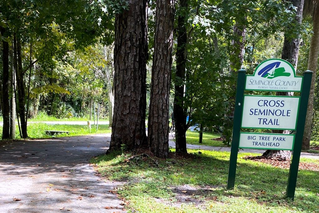
The Cross Seminole Trail is the best piece of transportation Winter Springs owns, and it is not a road. Seminole County counts roughly 23 miles of paved, multi-use trail running diagonally across the county — from the Cady Way Trail at the Winter Park line, through Oviedo, Winter Springs and Longwood, to the Seminole Wekiva Trail in Lake Mary — with stretches designated as the Florida National Scenic Trail and the corridor forming part of the statewide Florida Coast-to-Coast Trail. The Winter Springs miles are the trail’s suburban heart: shaded, neighborhood-threaded, and stitched directly into the city’s parks and its Town Center. Here is how to ride or walk them in Winter Springs.
The Winter Springs segments, south to north
Coming from Oviedo, the trail enters Winter Springs through quiet, upscale neighborhoods on what riders consistently call the prettiest part of the route — the original rail-trail section, wooded and calm. It reaches the Black Hammock Trailhead at 1571 E State Rd 434, the city’s principal trail access point, where Seminole County lists parking, restrooms and a drinking-water fountain. From there the trail crosses SR 434 on its own bridge — an overpass built so riders never have to play chicken with six lanes — and arrives at the Winter Springs Town Center, where the district’s restaurants sit steps off the pavement; our Town Center guide covers the eating options. North of the Town Center the trail passes Winter Springs High School and Central Winds Park, threads more neighborhoods, and continues toward Soldiers Creek and, across a US 17/92 overpass, Big Tree Park in Longwood. Choose a segment, not the whole 23 miles: Black Hammock to the Town Center is an easy family ride; Town Center to Central Winds and back makes a tidy morning.
The Spring Hammock detour
The trail’s wildest mile is its passage through Spring Hammock Preserve, just beyond the city line in Longwood — label it nearby, and do not miss it. The preserve protects over 1,500 acres of floodplain hammock and giant bald cypress on Lake Jesup, and its rebuilt Osprey Trail, reopened in 2025 with a paved path and new boardwalks, leads to a pier overlooking the lake and a walkway wrapped around a towering cypress. The preserve is also home to the Mud Walk, the famously mucky field trip taken by generations of Seminole County fifth graders, and it joined the Old-Growth Forest Network in 2025. From a Winter Springs trailhead it is a short ride and a complete change of world: suburb to old-growth swamp in under half an hour. Our Lake Jesup guide covers what waits at the boardwalk’s end.
Practical notes
The trail is paved and broadly flat — this is Florida rail-trail riding, where the enemy is sun and distance, not hills. Carry more water than you think you need between trailheads, start early in summer, and remember that the trail’s shade, generous in the Winter Springs neighborhoods, thins on the utility-corridor stretches further north. Trailheads solve the logistics: Black Hammock for the southern Winter Springs miles, Central Winds Park and the Town Center for the middle, Soldiers Creek Park beyond. Conditions and closures change with storms and county work, so a quick check of Seminole County’s trail pages before a long ride is the local habit. Families should treat the SR 434 bridge and the Town Center crossing as the natural turn-around points they are.
Why this trail defines the city
Most suburbs are experienced through a windshield. Winter Springs can be experienced at twelve miles an hour, under oak canopy, past the back fences of the neighborhoods the trail was built to connect — which is why we call it the spine of our Winter Springs guide. Ride it to lunch in the Town Center, ride it to a ball game at Central Winds Park, ride it into a cypress swamp. Then plot the whole line on our Orlando Top Spots Map and pick your segment.
Best for: cyclists, runners and walking families who want the real Winter Springs — the one that never appears from SR 434. The trail is the city at its best speed.
Photo: Mikasb, CC BY-SA 4.0, via Wikimedia Commons.
Orlando Citizen by email
The weekly edition, in your inbox
One email, every Saturday: the week’s edition of Orlando Citizen — the week’s stories, rankings and winners, gathered in one place. Free, and you can unsubscribe at any time.
Related Stories

Editor’s Picks
Spotted an error? Tell us — corrections · How we rank
